Wednesday, December 22, 2010

Final Project - Melting Ice in a Warmer World

What, where, why and who.


Objective:  My final project is a lesson on melting terrestrial ice and its effects on the planet.  The students will come away with a greater understanding of the causes and effects of melting terrestrial ice and the impacts this will have on Alaskans, both Native and non-Native.

Photo credit:  Teacher's Domain
Goals:  This lesson will be part of a unit on global warming and climate change.  The unit will involve lessons on the impact of several aspects of climate change, including changing habitats, changing length of seasons, invasive species and positive feedback loops from melting permafrost to melting snow and ice.  The lesson prior to this one will be on melting sea ice.  These lessons will also address how these changes will affect the Arctic regions and the indigenous people that inhabit them.

Rationale:  The reason for teaching this lesson - and the unit of which it is a part - is to help students see the connection between Western science, Native ways of knowing and the real world.  It is also to make the students aware of a very real and controversial topic that will affect their lives in many ways, for decades to come.

Photo credit: Teacher's Domain
Audience:  This lesson will be part of the curriculum of a high school Earth Science class with students in grades 10 through 12.  The students are all residents of the Kenai Peninsula with about 10% of the population being Native Alaskans from all over the state.

The meat and potatoes.


The lesson will start with a quick review of melting sea ice, which was addressed in the previous lesson.  This will be followed by a viewing of the video Arctic Climate Perspectives that is an excellent comparison of Western scientific knowledge and Native knowledge as well as a very good demonstration of how global warming affects the Inupiat people of Barrow, Alaska.  This will be followed by an informal class survey on the allotment of 1000 snowflakes and a subsequent visit on the smartboard to the USGS website page on glaciers and the answers to the 1000 snowflakes survey.  Then, a viewing of the Extreme Ice Survey video on the Mendenhall Glacier will be followed by
a visit to the Documenting Glacial Change interactive site.


After examining all this background material, we will discuss the day's assignment:  mapping the coastline of the Kenai Peninsula taking different amounts of sea-level rise into account.  As an example, we will visit the interactive site, Mountain of Ice:  If The Ice Melts and view changing coastlines of Florida, as well as the map of Antarctica.  We will also go back to the USGS site and view the Glaciers and Sea Level page.  We will record the change in sea levels for the various scenarios of glacial melt.  Then, the class will be broken into groups.  Each group will be given two topographical maps, either covering the northwestern half or the southeastern half of the Kenai Peninsula.  Some groups will be asked to map the coastline if a 20-foot sea level rise occurs due to Greenland's glaciers melting, while others will be asked to map the coastline if a 240-foot sea level rise occurs due to Antarctica's glaciers melting.  With colored pencils, the new ocean levels will be filled in in blue.  This may take a second class period to be completed and will be followed by individual short essays on how the various heights of sea-level change will affect life on the Peninsula, including subsistence hunting and fishing. 

Sunday, December 5, 2010

Module IX - Terrestrial Ice Systems

360 degrees of the Milky Way (Wikipedia.com)
Explain - What new learning have I taken from this module?

Though I was familiar with the process of gathering past climate data from ice cores and tree rings, I was suprised to find that such data has also been gathered from coral reefs and lake sediments.  I was also surprised to find that some of that data indicated past climatic changes more dramatic than those predicted by the present trend of global warming that took place in as little as one to three years!  The implications of the impact that would have on modern societies that are much less flexible than ancient hunter-gatherer societes are alarming.  Though the science behind the movie "The Day After Tomorrow" may be a bit questionable, the idea behind such a rapid climate change is becoming less far-fetched, in light of such evidence.
Glacier Bay to Hoonah, Ak - 91 miles (Google Earth image)

I found it interesting that the link to Wikipedia mentioned the possibility of some of our cyclical climate changes being due to our solar system's orbital journey through the galaxy.  Though I'm having trouble imagining how our changing position in the galaxy would effect our climate, the idea really does give credence to the idea that EVERYTHING is connected.

The exercie on Google Earth was quite enlightening, as well.  That must have been quite a task to move a village over 90 miles to get out of the path of an advancing glacier.  Imagine the monumental task ahead of the city of Miami, if it has to get pushed nearly to Georgia by advancing sea levels.


Tundra polygons, flight from Barrow to Atqasuk (photo:  D. Armstrong)

When I taught in Atqasuk, up near Barrow, I taught a couple of North Slope Science classes that I found to be very instructional for myself, as well.  I learned a lot about permafrost and some of the geological landforms of the Arctic.  Though we studied the effects of melting permafrost on the content of greenhouse gases in our atmosphere (yet another of those blasted positive feedback loops), I hadn't heard about the added complication of arctic lakes starting to drain when the "plug was pulled" by melting underlying permafrost.  A visiting group of scientists came to speak to my classes about the biology of the lakes in the area and the possibility of tapping the methane from one of the lakes to help generate power for the village.  In the end, that didn't prove to be cost effective, though the idea of converting methane into carbon dioxide, a more benign greenhouse gas, was inviting.  Imagine a remote village having a negative greenhouse gas footprint!

Extend and Evaluate - How can I use this week's resources and how useful, insightful or relevant are this module's information resources to me?

I found the visuals associated with the old and new photos of Alaskan glaciers on the Documenting Glacial Change interactive lesson very useful and will use that, next week, in my Earth Science class when we start studying glaciers.  Likewise, the Extreme Ice Survey will also be a very useful visual of yet another of Alaska's shrinking glaciers.  If the Ice Melts is another instructive visual, particularly if pictures of Florida's changing coast line are coupled with similar pictures of what the Kenai Peninsula would look like (I have yet to find those).   I will also use the video on the Fastest Glacier, on western Greenland's Jacobshavn Glacier.

Three colleagues and three comments

I enjoyed Carolyn's comment about changing the "big burp" to the "big fart" for the benifit of middle schoolers.  That will grab the attention of the high schoolers, as well, I'm sure.  At first, I thought her heading, "If it makes it to the dinner table, you win" was going to be a reference to subsistance hunting instead of what subject matters the students bring home to the dinner table conversation.  Either way, it still holds true.

It must be tough for Alison to get to spend a few days in Hawaii, especially at this time of year.  She mentioned how much of a disconnect there seems to be in the warmer climes when it comes to global warming.  True, but we seem to have such a disconnect right here in Alaska, as well.  I guess that's part of our jobs as teachers - to get that disconnect re-connected!

Konrad's blog had a great link to a virtual tour of the permafrost tunnel in Fairbanks.  He also had some great shots of the shrinking Portage Glacier.

Saturday, November 27, 2010

Module VIII - Cryosphere Introduction

Explain - What new learning have I taken from this module?

 It is easy to forget that the melting of sea ice doesn't actually change the level of the oceans.   This module was a great reminder of this and the associated experiment with the ice melting in the glass of water is a very good demonstration of that phenomenon.  This module pointed out that the bigger issue with melting sea ice is the fact that the albedo of ice and snow is much higher than that of open water.  Yet another one of those nasty positive feedback loops. 

The second page of the module pointed out some of the other effects of the melting sea ice.  Shishmaref is a coastal village bombarded by my more violent winter storms with much less ice to keep the waters down, resulting in alarming erosion of their little island.  Whalers in Barrow and hunters in Northern Canada have to adapt to much more difficult and dangerous conditions to get to their food.  Read more about that in Charles Wohlforth's The Whale and The Supercomputer.  If humans with their snow machines and motor boats are having a harder time of it as the sea ice vanishes, imagine the plight of the polar bear.

all photos:  D. Armstrong


Extend and Evaluate - How can I use this week's resources and how useful, insightful or relevant are this module's information resources to me?

I found the Our World 2.0 website to be an incredibly diverse source of articles on climate change and indigenous peoples around the world.  It would be a great place to send students doing research on those subjects.

I felt that the video on Shishmaref would be a great way to bring home to the students how global warming is already effecting people within their own state.  Climate change is not some distant phenomenon that effects only the people of New Orleans or some tropical atoll.

The NASA video on the Earth's cryosphere will be very instructional when introducing the cryosphere to students.  It is a great overview and does a great job of showing how changes in everything from Rocky Mountain snowpack to Greenlandic glaciers has an effect on the planet.

Lastly, of course, I can use the experiment with the melting glass of ice and water to demonstrate everything from melting sea ice to buoyancy and density.  The salt water experiment is also a good one.  Our physics classes already do a lab in which ice cream is made the old-fashioned way.

Three Colleagues


Dan's blog has a great link to Ian Guch's website with all sorts of free stuff for teaching chemistry.  Great site, Dan.

Janet's blog has a link to a very moving video of one man's personal experience with climate change.

Tyler's blog has a great shot of Mt. Redoubt erupting, a reference to Project Wild's excellent resources and a useful link to UAF's science forum website.


Sunday, November 21, 2010

Module VII - Changing Climate Introduction

Sample of coquina
credit:  http://www.gc.maricopa.edu/earthsci/imagearchive/coquina.jpg
Explain - What new learning have I taken from this module?

This module was a great reminder about the eons of natural carbon sequestration that has been taking place since the dawn of life on this planet.  I was amazed to learn how much life has changed the atmosphere and how life and the atmosphere have evolved in unison.  In light of how much carbon has been sequestered, this makes a lot of sense, though it's not obvious without being pointed out.

When discussing climate change, I have often pointed out that when you burn the wood of a tree, you are re-releasing the carbon into the atmsophere that that tree has been removing for the last hundred years, or so.  Likewise, when you burn oil, you are now going back millions of years and releasing the carbon that was sequestered, then.  I had heard about carbon sequestration in the form of calcium carbonate in the shells of animals, but hadn't really thought about what a vast cache of carbon this represents.  It is a bit depressing to think about the increased acidification of the oceans making it harder for organisms to precipitate calcium carbonate from the water.  Yet another positive feedback loop.

The video about Inuit observations of climate change reminded me of discussions with villagers, a few years ago, about how the winters along the lower Kuskokwim just weren't as severe as they were 20 years earlier.  One of my last years in Tuluksak, the mercury dropped below freezing in early October and didn't get above freezing until late March.  All of the older villagers said that was how winter was supposed to be.  It was the only such winter that I experienced, there, in five years.

Extend and Evaluate - How can I use this week's resources and how useful, insightful or relevant are this module's information resources to me?

Helix Nebula
Credit:  http://asymptotia.com/wp-images/2007/02/Helix_Nebula.jpg
The video The Elements - Forged in Stars brought me back to my Freshman Astronomy class in college.  I will use this in both my Earth Science class and my Physical Science classes.

I will also use the video Ingredients for Life - Carbon in my Physical Science classes when we touch on organic compounds and why such a vast variety of carbon-based compounds exist.

The video Global Warming:  Carbon Dioxide and The Greenhouse Effect shows a great demonstration of how effective carbon dioxide is when it comes to absorbing heat energy.  It's a great visual when the infrared image of the scientist's face disappears behind a chamber of carbon dioxide.

The Capturing Carbon clip will be a great motivator when it's time to put on a science fair.  How great is it that the scientist was able to put his daughter's project into actual use?

Three colleagues and three comments

- I agreed with Alison's comment about how amazing it is that the lowly parrot fish can create all that sand in the coral reefs.  It'll give me pause the next time I curl my toes into the coral sands of Hawaii.

- I enjoyed Kathy's photos on last week's blog.

- Marilyn's blog reminded me how powerful the images on the Information is Beautiful website are.  She also mentioned a song by Tom Lehrer that I, too, play for my classes when we study the elements.

Saturday, November 13, 2010

Module VI - The View from Space

Explain - What new learning have I taken from this week's module?


I found the information on toxins and haze accumulating at the polar regions rather sobering.  Ever since moving to the Kenai Peninsula, I have noticed what seems to be an inordinate amount of cancer cases amongst the local population.  This observation is completely unscientific, but it does make me wonder whether it's an effect of the local refineries or of toxic accumulation in the arctic regions.  If this does have anything to do with regional accumulations, then this is potentially devastating for Native people who live farther north and get a higher percentage of their calories from locally hunted and gathered food.  Compare the age-adjusted cancer death rate on the North Slope to that of the entire state of Alaska at this Census website.  Is there a connection?

The Native pilots video took me back to living in Bush Alaska and needing to fly to cross-country meets at neighboring villages and the general flying conditions in the state.  I have immense respect for Bush pilots and am fascinated by Alaskan aviation history.  Check out the book "Wager With the Wind" for one pilot's exciting biography.

I was amazed by the amount of information that can be gleaned from the silent video of global water vapor circulation over the period of a year.  Watching the slow, westward flow of equatorial moisture pile up against the Andes during the (northern) winter months made the cause of the Amazon's wet and dry seasons crystal clear.  Likewise, when things piled up against the Himalayas in the late spring and summer, the cause of Asia Minor's monsoon season suddenly made sense.

Extend and Evaluate - How can I use this week's resources and how useful, insightful or relevant are this module's information resources to me?
Cyclonic cloud formation off east end of Cuba

Again, I enjoyed the Google Earth exercise and liked the weather overlay.  When I get to weather with my Earth Science class, I will definitely be incorporating this into my lesson plans.  I'll also be using the TD interactive resources for atmospheric structure and the anatomy of warm and cold fronts.

I will also use the You Tube video "Making Ice by Boiling Water" when talking about the energy of phase changes with my Physical Science classes and Earth Science classes.  Of course, the danger of watching You Tube is getting side-tracked on unrelated themes - I spent half an hour checking out videos on superfluids.

Three colleagues and comments


Janet's blog has a great link to the Skeptical Science website and she pointed out that you can find webcam shots from within the Google Earth screen capture.

Dan's blog had some great information to get even more use out of your TD file by adding external links.

Kevin's Blog pointed out the close correlation of pollutants in Greenlandic ice cores and the changing activities of mankind.

Saturday, November 6, 2010

Module V - Ocean Systems

Explain - What new learning have I taken from this module?

Extra bouyant in the
Dead Sea
I found this module to be a fascinating one.  Ever since I was a kid I've been astounded by the superlatives of the ocean:  the 40,000-mile mountain chain, the depths able to swallow Mt. Everest, the worlds tallest mountain, the draw of over half of humanity to it shores - the list goes on and on.  As an adult, I became familiar with the significance of density diffences and temperature differences in the oceans through education, scuba diving and travel.  This module was a great synopsis of the factors effecting ocean currents,  world weather, resources and, ultimately, human societies.  I found the 1000- to 1600-year journey of a water molecule through the depths of the ocean to be fascinating.  Ever since doing some Cenote diving in the crystal-clear, fresh water of the Yucatan Peninsula's limestone caves, the halocline has fascinated me.  There, you can actually see the interface between fresh water and the salt water below.  It looks like a layer of clouds through which you can't see clearly from either below or above.  Check out this Youtube video of some divers going through a distinct halocline.  Every diver who has been in both fresh and salt water is familiar with the fact that you need more weights to compensate for your bouyancy in denser salt water than in fresh water and divers in the Dead Sea must need even more.

Extend and Evaluate - How can I use this week's resources and how useful, insightful or relevant are this module's information resources to me?

San Francisco at 37 degrees
46 minutes North
The most useful resource that I found in this module was the last half of the video about Ben Franklin's discovery of the Gulf Stream.  I found the animation of not just the warm surface current, but also the cool water dropping to the sea floor and returning to the Tropics to be a very good illustration of a fairly complex idea.  I would love to see such an animation that follows the entire 1000-year journey of a water molecule, but have been unable to do so, as yet.  I liked the demonstration with the lighter under the balloon.  It reminded of a trick I learned in Boy Scouts in which you can boil an egg in a paper cup over a campfire.  The paper burns away above the waterline, but stays intact where it's in contact with the water.  The exercise in GoogleEarth was also instructive, though I was unable to get the ocean temperature overlay to work.  I did, however, find a NASA image that shows the  difference between ocean surface temperatures on the two coasts of the U.S.  The cooler west coast waters certainly explain the cool, foggy summers of San Francisco, though the reason for Washington D.C.'s harsher winters is not as clear.
Washington D.C. at 38 degrees
53 minutes North
 
NASA image of ocean surface
temperatures


Blue, glacial meltwater staying atop salt water
at the Columbia and Valdez glaciers

 I also thought that the experiment with melting blue-colored ice in warm, red water, would be very demonstrative in showing the difference in density of cool and warm waters.  Finding evidence on GoogleEarth of a similar phenomenon would be very instructive for students, though I was disappointed to find no evidence of this at the mouth of the Amazon River.  This, despite that fact that sailors of previous centuries were able to encounter less-dense fresh water atop ocean water days before arriving at the mouth of said river.

 Three collegues and three comments

I enjoyed the link on Tyler's blog to the beachcomber's alert site that showed how you can learn about ocean gyres by beach combing.

Amy's blog pointed out how incredible it is that Ben Franklin was able to map the Gulf Stream so accurately without the use of GPS or modern scientific equipment.

Janet's blog had a great link to the Oceans Alive website with a map in which Pangea is reunited - a great visual to show how much of the planet is covered by oceans.


Saturday, October 30, 2010

Photo tour of the Ring of Fire


Mt. Redoubt chugging away, as seen from the Kenai Peninsula
Mt. Ranier looms over Seattle.
Mt. St. Helens lost about a cubic mile of material when it erupted and showered much of the northwestern U.S. with ash.
Crater Lake, in Oregon - a collapsed volcanic caldera.
Mt. Shasta, another volcano in the California portion of the Cascades


Mt. Lassen at the southern terminus of the Cascades.
Volcan Atitlan in Guatemala


Hike up Antigua's active volcano, Guatemala
Antigua and it's volcano.  Antigua is a colonial town that has been destroyed more than once by earthquakes.

Cerro Verde, near Sonsonate, El Salvador.  Growing coffee in the rich soil on the slopes of a volcano.
Caldera, Masaya Volcanic Park, Nicaragua


Omotepe Volcano from Masaya Volcanic Park, Nicaragua.  From this
vantage point, it is possible to see volcanoes of the Ring of Fire marching off in two directions.


Lake Omotepe and one of its two volcanoes, Nicaragua


Volcan Arenal erupting (about 20 times a day), Costa Rica
And again.
A pyroclastic flow down the flanks of Volcan Arenal.
Volcan Irazu, Costa Rica
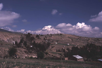
Mt. Chimberazo, Ecuador
Flight over the Andes from Quito to Cuenca, Ecuador
Volcanoes on the Bolivian Altiplano.
More volcanoes on the Altiplano
Volcan Lauca, northern Chile.
Lanin volcano, south-central Chile.
Volcan Osorno, southern Chile.
Volcan Hornopiren, Chilean Patagonia.
Torres del Paine, Chilean Patagonia.
Multi-colored crater lakes, Kelimutu, Isand of Flores, Indonesia
Steaming jungle, smoking volcanoes and ancient temples.  Borobudur, Java, Indonesia.
"Tsunami" is a Japanese word, after all.
Japan's signature volcano, Fuji-san.


Mt. Fuji sunrise from Kitadake, Japan.